Mule Deer Migration and Citizen Science
Northern Bighorns Mule Deer Migration Study – Calling all Citizen Scientists!
Collaborative Project with SCLT, Wyoming Game and Fish Department, Wyoming Migration Initiative, and The Nature Conservancy
What is the project?
Healthy mule deer populations are essential to sustaining the ecological, economic, and cultural values of our western landscapes. Increasingly, scientists and wildlife managers are recognizing that the productivity of these herds depends on their ability to migrate seasonally across vast expanses of public and private lands.
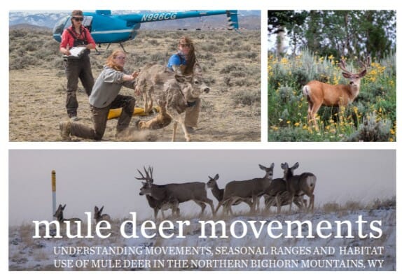
In the northern Bighorn Mountains, Wyoming Game and Fish Department, University’s Cooperative Fish and Wildlife Research Unit, and partners Sheridan Community Land Trust, The Nature Conservancy in Wyoming, and the Wyoming Migration Initiative have joined forces to fit 120 mule deer with satellite collars. The objective of the project is to create detailed maps of mule deer movement for the first time. This study will gather valuable information that can help stakeholders better understand mule deer seasonal habitats, habitat use and movement.
Armed with this information, decisions can be made with public and private land managers to conserve and improve habitats within migration corridors. It could also help inform potential transmission risks for Chronic Wasting Disease. Potential outcomes from the study include habitat improvements, guidance for forest planning, fence modifications, conservation easements and modifications to hunting season structure.
How you can help?
We need your help identifying locations of mule deer in the Northern Bighorns from July 1st through August 15th!
Scientists will be collaring 60 mule deer this summer in the Bighorns. They need your help in locating mule deer. You can contribute crucial scientific data useful to scientists and conservationists working to study and protect mule deer habitats, habitat use, and movement in the Northern Bighorns area while allowing scientists to complete collaring quickly and reduce the project’s overall cost. Plus, you can help the project on your way to your favorite camping site, fishing hole, trail, or out for a scenic drive.
Using the free smartphone app called iNaturalist, you will simply record the location of where you saw deer.
From July 1 – August 15, record and submit observations of mule deer in the Bighorn National Forest through the iNaturalist app on your phone.
How to use iNaturalist?
Before you head to the mountains:
- Create a free iNaturalist account and download the iNaturalist app for iPhone or Android.
- Click the box allowing “Yes, license my photos, sounds, and observations so scientists can use my data.”
- Make sure you allow iNaturalist to access your location, and that you have locations services turned on for your device. For iPhone and Android you can do this from the Settings menu.
- From the iNaturalist app’s Settings menu turn off Automatic upload. This will prevent iNaturalist from trying to upload your observations as soon as you save them. This prevents the app from trying to upload your observation when out of cell service range.
When you see a mule deer:
- Open the iNaturalist app
- Use the phone icon “Observer” to photograph the mule deer
- Click “Retake” or “Next”
- “What did you see?” – Type in mule deer
- Click “Save”
- When you get back to cell service or internet open the iNaturalist app and click “Upload” to share your observations
- Know you have helped this cool science project!
Additional iNaturalist Resources
iNaturalist can be used to record observations of all sorts of species. These resources can help if you want to know more:
- iNaturalist’s video tutorials>>>
- iNaturalist Tutorial PDF>>>
- iNaturalist FAQ>>>
- iNaturalist’s overview video>>>
Read an update on Winter collaring and deer movement from February 2021 >>>
Read an update from Winter 2020 collaring by project partner Christina Schmidt of WGFD >>>
Read an update from Spring 2020 collaring by project partner Christina Schmidt of WGFD >>>
Questions?
Contact Us Today: