What’s in a name? That which the Crow Tribe calls the Iisaxpúatahchee Isawaxaawúua, by any other name would be as beautiful.
A truism that Sheridan Community Land Trust (SCLT) Historical Program Manager Carrie Edinger set about to explore through the creation of three Bighorn Mountains interpretive signs that visitors to the Soldier Ridge and Red Grade trail systems can now view.
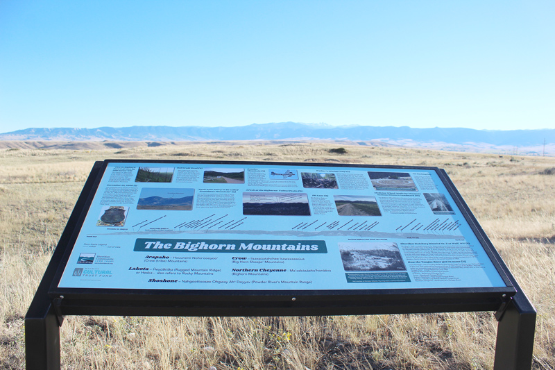
The two signs on Red Grade Trails highlight the history of the area around Red Grade Road, while another explores culture and heritage of Plains Indian Tribes. A third sign, located on The Link Trail, part of the Soldier Ridge Trail System, depicts a panoramic view of the Bighorns as seen from Soldier Ridge. It identifies prominent peaks, shares Plains Indian Tribes placenames and tells stories and locations of many historic events.
The goal, according to Edinger, is to help visitors to the trails develop a deeper sense of place by learning more about the land, history and culture that make Sheridan County so special.
“Telling these stories of local and regional history and culture on interpretive signs offers public accessibility to the various perspectives and inhabitants of the area, while being onsite where it is being depicted,” Edinger explained.
She was inspired to create the signs shortly after joining SCLT as an AmeriCorps VISTA. While exploring SCLT’s trails she was struck by beauty she could see from the trails and how closely the land she was on was tied to stories of the people and events she was researching.
“The idea for the signs was to bring local history and culture together with the recreational opportunities SCLT offers the community,” Edinger remarked. “The sites and content of the signs were chosen by historical research and observation of the landscapes from the SCLT trail systems.”
From there, she reached out to local, regional, state, federal and tribal groups in Wyoming, Montana and beyond with an invitation to have their voices tell their story through the signs. By the time she was finished, people from nearly 20 groups contributed to the stories presented on the three signs.
“The Sheridan County region offers many resources to historical and cultural information. It is a matter of reaching out and including these groups in the project,” Edinger said. “Consistent communication concerning what each group can offer to the project and the project’s process is a main element to having the large local and regional community input that we had for these three interpretive signs.”


Above: Trailside interpretive signs at Red Grade Trails tell stories about Plains Indian Tribes (left) and the history of Red Grade Road (right).
Getting the signs in the ground is the culmination of a project nearly two years in the making. However, Edinger has plans to create and install more interpretive signs that help people continue to connect with the history and people of our area so the people living in and visiting Sheridan County today can continue to develop a deeper sense of place.
Among them are updates to the Black Diamond Historic Trail interpretive signs and Tongue River Water Trail as part of a partnership with the Wyoming Department of Environmental Quality Abandoned Mine Land (AML). These updated signs will include mine safety information at each site while also incorporating historical and cultural information about each site.
Essentially, Edinger explained, visitors to either the Black Diamond or Tongue River Water trails will be able to drive or paddle through the region’s history.
“I am excited about bringing together local historical and cultural information with the recreational opportunities SCLT offers to the community and to be partnering with an organization like AML that brings the insight to recreate responsibly within the coal mine areas north of Sheridan,” she concluded.
Curt and Linda Schwamb generously shared their time to get the signs installed this summer.
You can find the Bighorn Mountain Panoramic sign on The Link Trail about 50 yards past the rollover cattle guard/pedestrian crossing just beyond the junction of Hoot Loop and The Link trails, both part of the Soldier Ridge Trail System. The Bighorn Mountain Heritage of Plains Indian Tribes sign can be found shortly after the beginning of the Prairie Loop as accessed from Red Grade Road at Red Grade Trails Base Trailhead. The History of Red Grade Road can be found just inside the entrance of the Tinker Trail loop that overlooks Red Grade Road at the Base Trailhead parking lot. Both the Prairie Loop Trail and Tinker Trail are part of the Red Grade Trails System.
Can’t make it? Copies of all three signs are on display at the Sheridan Travel & Tourism office located off I-90 at Exit 23. The Bighorns Panoramic sign is also on display at the Wyoming Room in the Sheridan County Fulmer Library.
Edinger said having the signs in several locations helps more people have easy access to the history and stories each sign shares. “As part of SCLT’s history program and community outreach, we are always looking for inventive ways to get the history projects to a wide range of people,” she concluded.
Regardless of their name, what the Northern Cheyenne Tribe calls Ma’xekȯsáeho’honáéva are always beautiful – and thanks to these three signs, you can explore them in a new way.
SCLT thanks the following people and organizations who helped create the material on the sign: Bighorn National Forest; Ben Rhodd, Rosebud Sioux Tribal Historic Preservation Office (THPO); Christina Schmidt, Wyoming Game and Fish Department; Crystal C’Bearing, Northern Arapaho Tribe THPO; Dave McKee; Donovin Sprague, enrolled member of the Minnicoujou Lakota Tribe and Sheridan College faculty; Fort Phil Kearny State Historic Site; Greg Nickerson; Joshua Mann, Eastern Shoshone Tribe THPO; Judy Slack, Big Horn City Historical Society; Lee McClure; Linwood Tallbull, Medicine Wheel Alliance and Northern Cheyenne Tribe; Nathan Barnes, BLM-Wyoming Buffalo Field Office; State Historical Society of North Dakota; Steve Stresky; Steve Vance, Cheyenne River Sioux Tribe THPO; Teanna Limpy, Northern Cheyenne Tribe THPO; Tempe Javitz; The Wyoming Room, Sheridan County Library System; Tim Bernardis and Tim McCleary, Little Big Horn College; Wyoming State Archives and all the community members who gave time to the development of the signage.
These trailside interpretative signs were made possible thanks to funding from the Wyoming Cultural Trust Fund.
Click here to view and print trail maps.
Click here to view pdf versions of the trailside interpretive signs.